CaspersCruiser
Well-known member
- Joined
- May 11, 2016
- Messages
- 947
- Fluid Motion Model
- R-27 Classic
- Hull Identification Number
- FMLT2709G112
- Vessel Name
- Cookie
- MMSI Number
- 368203460
I don’t want to beat a dead horse, but for those interested in such, here are some photos to illustrate heading/track/compass concepts discussed in some recent threads.
To review the terms used:
Heading is the direction the bow is pointing
Track (or course made good) is the direction the boat has been moving. Track is often different from the boat’s heading because of wind or current.
Heading and track may be referenced to True North or Magnetic North. True north is located at the geographic North Pole. Magnetic North Pole is located in northern Canada and it is the location to which magnetic compasses point. Magnetic north is almost always used for vessel navigation.
Magnetic variation is the difference between true north and magnetic north. Magnetic variation will change based on geographic location. For example, here in the Louisville, Kentucky area, magnetic variation is 5° west. In Philadelphia, it is 12° west. In Seattle it is 15° east.
Compass deviation is the error in a magnetic compass (usually +/- a few degrees) caused by magnetic influences around where it is installed. Airplanes from the smallest to the largest have a compass deviation card posted on their magnetic compass detailing the error on various cardinal headings. This deviation is actually measured by aligning the aircraft centerline on a “compass rose” painted on the ramp or through the use of a master compass. I’ve never seen a compass deviation card on a boat, but those errors surely exist.
Don’t get wrapped around the axle worrying about magnetic variation or compass deviation. Just make sure your chartplotter and autopilot compass are set to reference magnetic north.
The only time you have to worry about magnetic variation or compass deviation is if you plot a course on a paper chart, which are referenced to true north, and you want to navigate that course plotted on the chart using your magnetic heading instruments. Then you will have to apply magnetic variation and compass deviation. That circumstance is way beyond the scope of this post.
This morning, I took my R27 out on the Ohio River 15 miles upstream from downtown Louisville to photographically document some of these concepts. The river is at normal pool and there haven’t been any major rain events lately so the river is stable with a typical current of about 1 mph. Winds were flat calm.
I started out by crossing the river roughly perpendicular to the current at a fairly slow speed so the current would have a greater influence on what direction the boat tracked. This photo shows the results. Note that the direction displays on the autopilot compass and chartplotter have an “M” next to them to denote they are in degrees magnetic. Unfortunately, due to image size limitations of the forum, some of the finer details in these photos will not be possible to read.
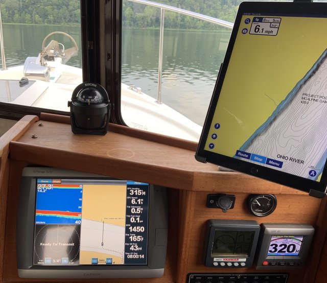
Autopilot compass display at the lower right shows heading is 320° (the direction the bow is pointing). Track is displayed on the chartplotter at the top of the far right column and is 315° (the direction the boat has been moving as influenced by the current). Track is shown on the Garmin 5212 under “GPS Heading”. That is a misnomer. It is a track!. Magnetic compass on top of the dash shows 317° (magnetic compass deviation in play here).
After my trip across the current, I turned parallel to the current (there was no wind) and this photo shows the results:
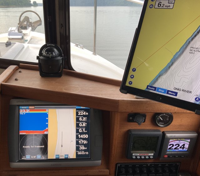
Heading and track are the same 224°. Magnetic compass 219° (again, magnetic compass deviation).
All of this may seem somewhat overwhelming, but if you’re completely unfamiliar with the concepts, I encourage you to get some training in them from someone who does understand them. It will make you a better captain and may come in handy if you have to navigate the old fashioned way or it may help you to detect nav equipment failure.
The iPad in the right side of the photos is displaying the Navionics app. I use it for its always up-to-date cartography and better bottom mapping.
To review the terms used:
Heading is the direction the bow is pointing
Track (or course made good) is the direction the boat has been moving. Track is often different from the boat’s heading because of wind or current.
Heading and track may be referenced to True North or Magnetic North. True north is located at the geographic North Pole. Magnetic North Pole is located in northern Canada and it is the location to which magnetic compasses point. Magnetic north is almost always used for vessel navigation.
Magnetic variation is the difference between true north and magnetic north. Magnetic variation will change based on geographic location. For example, here in the Louisville, Kentucky area, magnetic variation is 5° west. In Philadelphia, it is 12° west. In Seattle it is 15° east.
Compass deviation is the error in a magnetic compass (usually +/- a few degrees) caused by magnetic influences around where it is installed. Airplanes from the smallest to the largest have a compass deviation card posted on their magnetic compass detailing the error on various cardinal headings. This deviation is actually measured by aligning the aircraft centerline on a “compass rose” painted on the ramp or through the use of a master compass. I’ve never seen a compass deviation card on a boat, but those errors surely exist.
Don’t get wrapped around the axle worrying about magnetic variation or compass deviation. Just make sure your chartplotter and autopilot compass are set to reference magnetic north.
The only time you have to worry about magnetic variation or compass deviation is if you plot a course on a paper chart, which are referenced to true north, and you want to navigate that course plotted on the chart using your magnetic heading instruments. Then you will have to apply magnetic variation and compass deviation. That circumstance is way beyond the scope of this post.
This morning, I took my R27 out on the Ohio River 15 miles upstream from downtown Louisville to photographically document some of these concepts. The river is at normal pool and there haven’t been any major rain events lately so the river is stable with a typical current of about 1 mph. Winds were flat calm.
I started out by crossing the river roughly perpendicular to the current at a fairly slow speed so the current would have a greater influence on what direction the boat tracked. This photo shows the results. Note that the direction displays on the autopilot compass and chartplotter have an “M” next to them to denote they are in degrees magnetic. Unfortunately, due to image size limitations of the forum, some of the finer details in these photos will not be possible to read.
Autopilot compass display at the lower right shows heading is 320° (the direction the bow is pointing). Track is displayed on the chartplotter at the top of the far right column and is 315° (the direction the boat has been moving as influenced by the current). Track is shown on the Garmin 5212 under “GPS Heading”. That is a misnomer. It is a track!. Magnetic compass on top of the dash shows 317° (magnetic compass deviation in play here).
After my trip across the current, I turned parallel to the current (there was no wind) and this photo shows the results:
Heading and track are the same 224°. Magnetic compass 219° (again, magnetic compass deviation).
All of this may seem somewhat overwhelming, but if you’re completely unfamiliar with the concepts, I encourage you to get some training in them from someone who does understand them. It will make you a better captain and may come in handy if you have to navigate the old fashioned way or it may help you to detect nav equipment failure.
The iPad in the right side of the photos is displaying the Navionics app. I use it for its always up-to-date cartography and better bottom mapping.